We've decided to focus our immediate efforts on the areas excavated by N. Muller between 1904-1906 and published in both Die judische Katakombe am Monteverde zu Rom (Leipzig, 1912). and "Il cimitero degli ebrei posto sulla via Portuense" Rendiconti della Pontificia Accademia Romana di Archeologia 2.12 (1915) 205-318.
This decision was made for the following reasons. Firstly, making digital or virtual models of all of the different regions of the catacomb that have been discovered (cf. post "Summary of Published Areas") would of both limited viability and utility. The Muller excavations standout amongst for several reasons. First, they comprise, without any doubt, the largest and most sustained exploration of the Monteverde catacomb group. Secondly, they are the best published, and are the only to include a plan with orientation (though lacking in scale).
For all this, there are still substantial problems with reconstructing based on the Muller publications. For one, there remain both literal gaps in the plan between regions (which digital modeling may help to fill in) and gaps in the description and documentation that allows us to conceptualize the catacomb. For the latter (and to some extent for the former), comparative evidence will be critical. This means both comparative evidence that can be gleaned from the less well published areas of Monteverde Jewish catacomb group, and also from Christian and Pagan catacombs nearby (particularly of S. Ponziano).
Tentative breakdown of responsibilities, after re-prioritization:
Brendan Saslow: leading modeling efforts.
Sean Burrus: Muller publications, reviews of the excavations.
Jesse Hoffman: Comparanda from non-Muller excavated areas of Monteverde.
Laura Puleo: Comparanda from Christian and Pagan Evidence.

Thursday, March 24, 2011
Data-Mining: Vismara V - Conclusion on Muller
The following information, Vismara's survey of Mullers earliest excavations (1904-1906) will be critical to our initial phase of reconstruction on this, the best documented of areas.
--
- Muller describes a brick lined, barrel-vaulted vestibule averaging 2m wide, and oriented SE-NW. Connected to this vestibule with the same orientation was a staircase, 3m wide.
- If we accept Vismara's correction to Muller's plan of the regions explored between 1904-1906 (ie. that the image was mirrored, and E/W were inverted), then a few possible areas are indicated.
- Muller also found remains that suggested to him an upper catacomb that post-dated the lower. Muller describes the area only briefly and provides scant reasoning. Vismara questions his assertions here, which are based on bricks and inscriptions that could have been turned up in landslides, he argues. It does seem that Muller's suspicions of an upper catacomb are more likely a collapsed portion of the same extant catacomb.
--
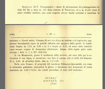
Data Mining: R. Pasqui, "Regio XIV" Notizie degli scavi di antichità (1911)
Regione XIV. Proseguendosi I lavori di sistemazione del prolungamente del viale del Re, a circa m. 400 dalla stazione di Trastavere, ed a m. 11,50 sopra il piano stradale moderno, sono state scoperte alcune tombe costruite a cassettoni in muratura a diversi ordini. Ciascuno di essi era diviso da mattoni o da tegole che poggiavano lateralmente sopra un piccolo battente che sporgeva dale pareti. Le tombe erano lunghe m. 1,70, m.1,85 e m. 2 e larghe m. 0,45, ed erano state costruite sopra terreno vergine di formazione alluvionale. Alcune delle tegole quivi usate avevano I bolli C. I. L. XV, 282.764
In via Monteverde, presso il cavalcavia della ferrovia, nei cavo fatto per la costruzione di una fogna, si rinvennero: una base di marmot, alta m. 0,20, del diametro di m. 0,50, ed un’anfora fittile, alta m. 1 x 0,30.
Nella cava Brunori, di proprieta del marchese Pellegrini-Quarantotti, ove erano le catacombe gindaiche, estraendosi la pietra, si rinvennero due frammenti di lastra marmoreal (m. 0,32 x 0,18), che rinniti presentano il resto dell’iscrizione:
TRANSLATION (in progress): Region XIV. Continuing the work of installation of the extension of King Avenue, about m. Trastavere 400 from the station, and m. 11.50 above the modern road, were discovered some tombs built coffered walls of different orders. Each of them was divided by bricks or tiles which rested on a small side door that stuck dale walls. The graves were long m. 1.70, m.1, 85 m. 2 m wide and 0.45, and had been built on virgin soil of alluvial formation. Some of the tiles used there had C. Stamps I. L. XV, 282,764
By way of Monteverde, near the railway bridge, in cavity made for the construction of a sewer, were found: a base of marmot, tall m. 0.20, m in diameter 0.50, and clay amphora, tall m. 1 x 0.30.
Brunori in the quarry, owned by the Marquis Pellegrini-Quarantotti, where the catacombs were gindaiche, removing the stone, were found two pieces of sheet marmoreal (m. 0.32 x 0.18), which have renewed the rest of the entry:
Thursday, March 17, 2011
Photos from De Angelis D'Ossat's Visit (1930's)
The following photos come from De Angelis D'Ossat's 1943 La Geologia Delle Catacombe Romane (Roma Sotterranea Cristiana, vol. III). Note the markers on the first two photos that correspond to the geological layers:

- 14: Loose sandy loam and fluvial accumulations.
- 13: Reddish semi-lithoid tufa.
- 12: Vulcanic detritus
- 11: Homogenous lithoid tufa, subtly striated.
- 10: Lithic tufa, used for construction

"Photograph of the Last Remnant of the Jewish Cemetery"
Subcaption: The gaping hole reveals the remains of a series of niches in significant decay. The two black lines mark the thickness of layer 12 (approx. 1.2 m).
 "Photograph of the Last Remants of Jewish Cemetery"
Subcaption: To the right, one can see the remants of a series of decaying niches.
Subcaption: The gaping hole reveals the remains of a series of niches in significant decay. The two black lines mark the thickness of layer 12 (approx. 1.2 m).
 "Photograph of the Last Remants of Jewish Cemetery"
Subcaption: To the right, one can see the remants of a series of decaying niches.
A Schematic Plan of the Geological Strata


Data Mining: Vismara IV - Muller 1904 on
Vismara on Muller's Early Excavation:
- Notes catacombs 6 meters below the ground.
- 50 meters away from the city walls in a valley.
- Caves, tunnels and cubiculae almost completely destroyed.
- Because of the quarrying activity, it was possible to get a read on the stratigraphy of the area (cf. Muller, Il Cimitero, 220)
Summary of published areas
A) A. Bosio, 1602, Roma Sotterranea (1650).
--- NO PLAN
B) N. Muller, 1904-6, Die judische Katakombe am Monteverde zu Rom (Leipzig, 1912).

C) R. Pasqui, 1911, "Regio XIV" Notizie degli scavi di antichità (1911) 39-40.
--- NO PLAN
D) G. Schneider Graziosi, 1913, "La nuova sala giudaica nel museo cristiano lateranense" Nuovo bullettino di archeologia cristiana vol. 21 iss. 3 (1915) 13-56.
E) R. Paribeni, 1919, "Iscrizione del cimitero giudaico di Monteverde" Notizie degli scavi di antichità (1919) 60-70.
--- NO PLAN
--- NO PLAN
B) N. Muller, 1904-6, Die judische Katakombe am Monteverde zu Rom (Leipzig, 1912).

C) R. Pasqui, 1911, "Regio XIV" Notizie degli scavi di antichità (1911) 39-40.
--- NO PLAN
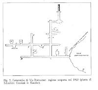
D) G. Schneider Graziosi, 1913, "La nuova sala giudaica nel museo cristiano lateranense" Nuovo bullettino di archeologia cristiana vol. 21 iss. 3 (1915) 13-56.

- Near the entrance to the Catacomb of Ponziano in a vineyard owned by the Rey family (Russo, 14).
- The "region" had its own entrance (Russo, 14).
- Plan (above) shows 5 cubicula, one "niche," and one absis tomb (Q)(Russo, 14).
- The staircase linking this hypogeum to the surface level was reinforced with walls of opus listatum (Russo, 32, 196n. citing Kanzler [1915] 156).
E) R. Paribeni, 1919, "Iscrizione del cimitero giudaico di Monteverde" Notizie degli scavi di antichità (1919) 60-70.
--- NO PLAN
Data Mining: Vismara III
Summary (of Vismara's Summary) of Bosio's Account (p363):
- Bosio only explored for two hours and produced no precise plan.
- Bosio indicates two cubiculi, very small, and went to lengths to emphasize the modesty of the cemetery (remarks about the complete lack of sculpted marble).
- Notes that almost every burial had a menorah (7 branches) incised or painted in red in the [loculi sealing] cement.
- Tombs were sealed with bricks and plaster, on which was painted or inscribed an inscription.
- The tombs were carved in both the walls and the floors.
Data Mining: Vismara (cont)
On the geology of the area:
- The tufa of the Monteverde region was 'celebrated' and quarried for construction material, leading to a landslide in the area.
- The catacombs were excavated in the less compact upper strata.
- Scholar De Angelis d'Ossat conducted a study of the geology of the area published in 1939 (La geologia delle catacombe romane, in Roma Sotterranea Cristiana III, Cita del Vaticano).
- De Angelis d'Ossat divides the catacombs in the following way (from bottom to top; pp23-25 and fig. 8 of the publication):
- ---30m-10m : tufa of lithoid construction (tufo litoide da costruzione) which was partially visible in the quarries.
- ---10m-7m: homogenous, fine grained and with minute stratification, easily fractured.
- ---7m-6m: coarse black volcanic debris with detritis, of non-homogenous and permeable granular volcanic tufa. It was in this layer that the majority of catacombs were dug.
- ---6m and above: sandy loam and limestone layer.
Friday, March 4, 2011
Roberto Paribeni - Photo of Monteverde Catacomb (1919)
 Roberto Paribeni, "Iscrizioni del cimitero giudaico di Monteverde" Notizie Degli Scavi di Antichità v.16 (1919) p. 60.
Via Portuense. Iscrizioni del cimitero giudaico di Monteverde. — Lavori di mine
per l'estrazione di tufo litoide han fatto crollare altri tratti di galleria del noto cimitero giudaico di Monteverde, che per le disperate loro condizioni di sicurezza non fu possibile salvare negli anni delle maggiori scoperte, e di cui non rimane ora che il breve tratto di galleria inaccessibile rappresentato nella nostra fotografia (fig. 10).
TRANSLATION: Via Portuense. Inscriptions of the Jewish cemetery of Monteverde. - Mining activities for the extraction of lithoid tufa have brought down other sections of the tunnel of the well known Jewish cemetery in Monteverde, from which, due to the desperate safety conditions, it was not possible to save years of major discoveries, and from which the short stretch of tunnel shown in our photograph does not now remain inaccessible (Fig. 10).
Thursday, March 3, 2011
Data Mining: Vismara, I cimitieri ebraici a Roma (1986)
Vismara is noted in other works as providing a comprehensive discussionof the geology of the area. He also includes a plan of a section of the catacombs discovered (and planned) by Muller in 1913, previously unknown to us (below).


Other information from Vismara. On location:

Other information from Vismara. On location:
- Not far from the catacombs of Pontiana [the catacombs of Pontiana ARE planned by Bosio, a fact we discovered yesterday while browsing the 1659 edition of Bosio's Soterraneo]
- Between Pontiana catacombs and the present Trastevere rail station.
- Dug into the hillside of the Monteverde
- Agrees with the general discussion of the difficulties of study confronting early scholars because of instability in the galleries and landslides.
- Notes the long duree in which scholars lost track of the catacombs, citing the difficulty of Marucchi and Marchi in determining the location (just like us!) which led de Rossi to conclude in 1864 that the entirety if the catacombs had collapsed.
- The region discovered in 1904, Vismarra notes, was likely not the same one as noted by Bosio
- A region in similarly precarious state of preservation
- Also on the via Portuense
- Documented in a breif notice including schematic plan (without orientation and lacking scale) with transcriptions of the epigraphi and brick stamps found therein.
- THIS region had already been destroyed by 1915 and Frey saw only a small portion of it.
- The remainder was permanently destroy in a collapse in 1929.


Data Mining: David Noy on the location of the Monteverde Catacomb
David Noy, Jewish Inscriptions of Western Europe: The City of Rome (1995).
TRANSLATION:
Region XIV. Following the renovation of the extension of viale del Re, about m. 400 from the Trastevere station, and m. 11.50 above modern street level, were discovered some tombs built in coffered masonry in different orders. Each of them was divided by bricks or tiles which rested on a small side door which hung from the walls. The tombs were long m. 1.70, m. And 1.85 m. 2 m wide and 0.45, and were constructed above the virgin soil of alluvial formation. Some of the tiles used there had stamps C. I. L. XV, 282.764.
By the via di Monteverde, near the railway bridge, the cable made for the construction of a sewer, were found: a marble base, tall m. 0.20, diameter M 0.50, and clay amphora, tall m. 1 X 0.30.
In the Brunori quarry, owned by the Marquis Pellegrini-forty-eight, where Jewish catacombs were, removing the stone, were found two pieces of sheet marble (0.32 m X0, 18), which together have the rest of the entry:
- A catacomb on the Via Portuense was discovered by the 'Columbus of the catacombs', Antonio Bosio, and two friends on 14th Dec. 1602, on a vineyard on the Colle Rosaro, i.e. Monteverde (between the modern Via Vincenza Monti and Circonvallazione Gianicolense, about 400m. west of Trastavere station). This site may be referred to in the writings of Benjamin of Tudela (tr. M.N. Adler, London, 1907), who visited Rome in the 1160s. He wrote (p. 10): ‘There is also a cave in a hill on one bank of the Tiber where are the graves of the Ten Martyrs.’ The catacomb was reached through an opening in a cliff overlooking a quarry (1).
- [Late 1904 rediscovered and identified by N. Muller]: The excavations were hampered by the perilous condition of the catacomb (much of which had already been destroyed by quarrying and landslides)… The only available [plan] is in Muller (1915), reproduced with slight alterations reproduced with slight alterations as Plan 2 in this book; it suggests that the excavated area may have been less than a quarter of the original catacomb (2). Vismara (1986) p. 362, observes that nothing in it matches Bosio's description, which is likely to refer to a different part of the catacomb.
- The remains of the catacomb were largely destroyed by a landslide on 14 Oct. 1928, and blocks of flats were later built on the site (Leon [1960]), figs.6-7). (3).

Important tidbits gleaned elsewhere:
- The quarry in Muller’s time was known as cava Brunori
- The property owner was Marchesi (the Marquis) Pellegrini Quarantotti (Fortyeight)
- The property address was via di Monteverde no. 5

TRANSLATION:
Region XIV. Following the renovation of the extension of viale del Re, about m. 400 from the Trastevere station, and m. 11.50 above modern street level, were discovered some tombs built in coffered masonry in different orders. Each of them was divided by bricks or tiles which rested on a small side door which hung from the walls. The tombs were long m. 1.70, m. And 1.85 m. 2 m wide and 0.45, and were constructed above the virgin soil of alluvial formation. Some of the tiles used there had stamps C. I. L. XV, 282.764.
By the via di Monteverde, near the railway bridge, the cable made for the construction of a sewer, were found: a marble base, tall m. 0.20, diameter M 0.50, and clay amphora, tall m. 1 X 0.30.
In the Brunori quarry, owned by the Marquis Pellegrini-forty-eight, where Jewish catacombs were, removing the stone, were found two pieces of sheet marble (0.32 m X0, 18), which together have the rest of the entry:
Subscribe to:
Posts (Atom)